When TripIt launched our Neighborhood Safety Scores feature (which shows safety scores for a variety of categories in neighborhoods spanning the world), little did we anticipate a global pandemic. Fast forward two years, and the safety risks for travelers suddenly look far different than they did in 2018—or even just a few months ago.
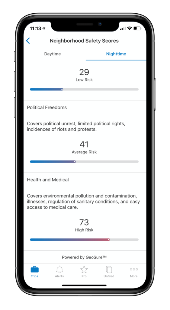
TripIt shows safety scores from 1 to 100, representing low to high risk, including a Health and Medical score that factors in COVID-19 data. This information is available in the Neighborhood Safety Scores section within each location on your TripIt itinerary with an address.
We spoke with Michael Becker, CEO of our partner, GeoSure®, which powers our Neighborhood Safety Scores, to better understand how COVID-19 data is sourced and incorporated within TripIt.
How does GeoSure factor COVID-19 data into the Health and Medical score?
Michael Becker (MB): GeoSure collects a vast number of signals (i.e. “data”) pertaining to current health and medical conditions at city and neighborhood locations across the globe. When we started to detect signals indicating a major health emergency in Wuhan China in late January, we began to collect new signals to ensure our Health & Medical Safety scores were even more accurate and relevant to the pandemic as it spread.
Where does GeoSure get that data?
MB: Health & Medical Safety scores are derived from a combination of well-known resources including, but not limited to: Johns Hopkins University, CDC, WHO, local health agencies and response/recovery organizations. Additionally, large volumes of unstructured signals are analyzed, (such as local sentiment), along with certain less-traditional predictor variables of spread, (such as the velocity and “viscosity” of migration/travel). As a data science and risk modeling platform, GeoSure’s expertise is in taking tens of thousands of disparate variables and making them more accessible, understandable, and consumable for travelers.
Did GeoSure add new data sources as a result of COVID-19?
MB: In the wake of COVID-19, we added data sources including infection rates, recovered patients and population migration data, as well as non-traditional signals such as travel patterns, government ordinances and supply chain activity, plus trend analysis. These data sources are now modeled, vetted, and reflected as part of GeoSure’s Health & Medical Safety ratings.
Easily access Health and Medical Safety Scores in TripIt, today
Travelers can access hyper-local Health & Medical Safety ratings, as well as the other safety categories, along any point within their TripIt itinerary for more than 65,000 cities and neighborhoods for both daytime and nighttime. This helps users visualize and gain an understanding of current safety conditions by location.
- Overall safety: objective measure of the safety quality at a location reflecting a average of the sub categories below
- Health and medical: environmental pollution and contamination, illnesses, regulation of sanitary conditions, and access to medical care
- Physical harm: including muggings, drug activity, gang prevalence, and police presence
- Women’s safety: including verbal harassment, physical assault, violence directed against women, and adequacy of women’s support facilities
- Political freedoms: including political unrest, limited political rights, and incidences of riots and protests
- Theft: including petty theft, pickpocketing, burglaries, auto theft, and grand theft
- LGBTQ safety: including likelihood of harm or discrimination against LGBTQ persons or groups and level of caution required at location